By Joseph P. Kaehler
By Joseph P. Kaehler
Foreword by Robert L. Zinn
When we were 11 years old, Joe Kaehler and I established a strong bond revolving around bicycles and mischief. When we were 30, our lives were completely different. Our energy was now focused on family and hard work. But that was about to change.
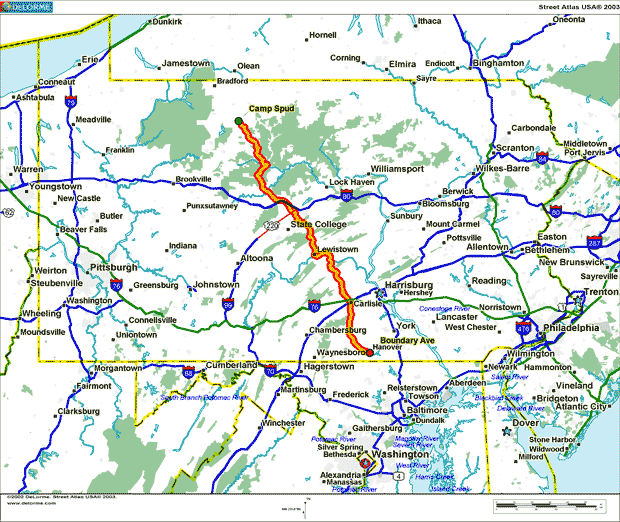
One February night in 1991, Joe called me on the phone with an interesting idea. He wanted to ride his bike 200 miles across Pennsylvania in three days. The trip would start from his hunting camp in Betula and continue to his home in Hanover. At first, I liked the idea, but the achievement of riding 70 miles for three consecutive days did not seem that great. Years ago, I had completed more 70-mile rides than I could remember. During the next few weeks, I continued to think about Joe's plan, and began to take a close look at the route and terrain of the trip. I looked at adjusting the trip plan to take just two day, but there was no place near the middle of the ride to spend the night. Then a nagging thought kept reoccurring in my mind: "Ride the 200 miles over eight mountains, in one day." Yes, one day! Back in 1984, I missed an opportunity to ride over 200 miles in a day with an old riding buddy. At the time, I was in prime cycling shape, but I did not think I could do it. For the past 10 years I regretted that decision and Joe's idea was an opportunity for me to attempt a ride I once thought to be impossible. More so, it was an opportunity to renew that close youthful friendship with Joe that I often reflect upon as the best times of my life.
Now, all I had to do was convince him that we could do this trip in one day. Here is Joe's story of an adventure of two friends and their bikes.
__________________
Many years ago when I was in the fifth grade, I met someone who became a new friend. His name is Bob Zinn. For most of the twenty-five years of our friendship, cycling has been our common thread. As kids, we traveled as far as our "sting-ray" bikes would take us. Often, when we had a day off grade school, Bob, a few other brave adventurers, and I would ride our bikes to Gettysburg, Pennsylvania. We would tour the famous Civil War battlefield all day and then make the return trip to Hanover, Pennsylvania. Pedaling forty miles or more on these trips was very common. Amazing, considering the bikes, we were riding.
As we went through high school, getting jobs and drivers' licenses placed cycling on the back burner for a few years. This changed shortly after Bob and I graduated from high school in 1980 and 1979 respectively. Bob went to college and found his forte in competitive racing, while touring on my bike suited me just fine. Occasionally, we would get together for a ride. Ten years passed before the two of us could manage to do significant hikes again.
 In July 1991, Bob and I did a one hundred sixty five-mile bike hike on the Chesapeake and Ohio Canal in Maryland. Our excursion originated in Great Falls, Maryland, thirteen miles northwest of Washington, D.C. Heading westward along the Potomac River, we made overnight stops at Harpers Ferry, West Virginia and Hancock, Maryland. On the third day of riding the towpath, we reached our destination at Paw Paw, West Virginia. During this trip, Bob and I concluded that we were not ready to be put out to pasture. The canal trip inspired us to do something more challenging.
My brothers and I own a cabin in Betula, Pennsylvania. This village in McKean County is two hundred miles north of Hanover, Pennsylvania. Bob and I set our sights on this cottage for our next challenge. Our goal was to ride our bicycles from Betula to Hanover. Given the distance and terrain, Bob and I had an enormous task ahead of us training and planning for this endeavor. Unfortunately, commitments to families and jobs delayed our journey a few years.
In 1993, we were still unable to commit the resources (time, training, etc.) necessary for our Betula hike. Fortunately, all was not lost. Instead, we chose to do another C&O Canal hike with two of Bob's friends, Neal Gerhart, and Joe Kostrubiak. This time we rode in the opposite direction of our 1991 hike. Bob, Neal, Joe, and I started in Paw Paw, West Virginia. We cycled southeastward with overnight stops at Williamsport, Maryland and Harpers Ferry, West Virginia. On the third day, the four of us completed our journey at Great Falls, Maryland. To put it simply, this trip was one hundred and sixty-five miles of fun.
In July 1994, I participated in a two-day charity bike hike for Multiple Sclerosis. There were over nine hundred cyclists in this one hundred fifty-mile, two-day event. The support was endless and the camaraderie overwhelming. A particular person stands out in my mind from that weekend. I met a man, seventy-four years of age, who had taken up cycling just a few years earlier. This man's enthusiasm was an inspiration. I often thought, "if he could do it, then anybody can!"
________________
In the fall of 1994, Bob and I commenced planning for the Betula bike hike. Both of us became excited about finally making definite plans for our upcoming 1995 cross-state ride. Bob's eagerness sent him to his computer that very night to start figuring topography and elevation charts. Although the planning process was in its infancy, the previous three years had given us time to gather ideas for this trip. There were plenty of questions that needed answers. Such as how many days would we need to accomplish our goal? When would be a suitable time to do it? Would Bob and I start in Hanover and pedal toward Betula or vice versa? What about overnight accommodations and would it be necessary to secure a support team?
The first item Bob and I labored over was the amount of time needed for a successful trip. Initially, we started with a three-day plan. This option amounted to seventy miles of cycling per day. Pedaling this distance probably would be effortless. We quickly scratched that idea. The next obvious choice was a two-day trip. This approach would give us two back-to-back hundred mile rides. From a physical point of view, Bob and I were capable. However, there were no overnight accommodations in the area where we would likely be finishing our first day. Reluctantly, we accepted the two-day option until mid-May 1995, when Bob did some number crunching and thought our trip could be done in a single day. I'm mostly an optimistic person, but I felt a streak of pessimism creeping up on me regarding this idea. Two hundred five miles in one day! Is he nuts? I had trouble swallowing this one. However, after a few days of thought, I accepted the challenge. I'll try it and see what happens.
After Bob (and I) narrowed our trip down to a single day event, our next step was choosing a date. Riding in the dark was not an option. So it was essential to use a day with maximum hours of sunlight. The day with the most hours of sunlight occurs each year during the summer solstice on June 22. This date fell on a Thursday in 1995, so we chose the following weekend as our tentative date. With June 24, 1995 as our target date, Bob and I selected the following two weekends as alternatives in case the weather did not cooperate. Calculating the daylight hours, this three-week period was our best window of opportunity.
Our planning was progressing steadily. Next on the agenda was the direction of travel. Starting in Betula was the indisputable choice. Bob and I figured on getting the higher elevations out of the way early in the day. By crossing the state from north to south, we would be riding unnoticeably downhill. Betula's altitude is 1900 feet above sea level compared to Hanover's height of 600 feet. Little by little, Bob and I whittled away at the details of our trip. With the single day option, we were left with no choice but to secure a support team. We simply could not fit all the necessary equipment into panniers (saddlebags). Food and drinks alone would have taken up all the space. Start adding tires, inner tubes, pedals, clothes, etc., and we would have a weight problem. Ideally, the less Bob and I had to carry; the easier we could climb the mountains. We settled this matter quickly. There was plenty of time to select two people for our support team.
The final detail that Bob and I were eager to pursue was mapping out a training blueprint. All the previously mentioned items of the planning process were vital. However, the two hundred mile journey demanded a training program designed specifically for this type of ride. We planned two fifty-mile hikes and a seventy-mile hike in April. Additionally, two-century rides were scheduled in May. Meanwhile, Bob and I intended to occupy ourselves with smaller rides between these larger hikes. We formulated a plan that made our training program nearly identical to our Betula trip.
__________
Cycling two hundred miles in a single day demanded not only good planning but plenty of quality training as well. Bob and I started with small rides to familiarize ourselves with each other's riding style. Despite all the years we had been riding together on sting-ray bikes, we seriously had to learn more about one another's strengths and weaknesses. This approach took time and patience. While riding, Bob and I shared information on our physical status, appetite, attitude and so on. For this to be truly a team effort, we had to train as a team.
The bicycles that Bob and I have endured for the past sixteen years would carry us through the 1995 season also. Since 1979, Bob has relied on his Soma Sport twelve speed bike. After several overhauls, this revamped 24 and a half pound, twelve speed, now bears the name "Sweetheart II." While Bob was attending Shippensburg University, a roommate crashed this bike in their college dormitory. With a severely bent frame, Bob chose to replace the mangled mess with a used, but nimble, chrome-moly steel frame. The only remaining original parts are the crank arm, handlebar stem and the seat post. After thousands of miles of wear and tear, the rest of the bike has been replaced. For his setup, Bob's handlebar stem extends 4.50 inches. His saddle is positioned as far back as possible. The distance between the front of his saddle to the back of his handlebars is 20.75 inches. This arrangement sets him up aerodynamically for downhill and flat runs, while allowing a comfortable position for climbing. In anticipation of the high mountains, Bob switched his front chain ring from a 39-teeth to a 36-teeth ring. This small adjustment gave him a lower gear for the steep ascents. Bob's 36/53 chain ring and his freewheel gearing of 13 through 32 provided the necessary variety for this year's riding.
My mode of transportation for this season was a Soma Cosmopolitan bicycle. I bought this 32-pound steel frame, ten speed bike in 1979. At the time, I thought the bigger the bike the better. This 24-inch frame bike is a bit large for me, but it makes for comfortable riding. The only specific change for this year was that I replaced all the spokes in my rear wheel. Having broken a few spokes over the years, this rebuilt rim certainly gave me peace of mind. Unlike Bob's setup, I like my saddle positioned forward to place me directly above the pedals for maximum power. Additionally, this helps me make a smooth transition when switching my grip on the handlebars from the hoods to the aerobars. Complementing my 40/53 chain ring gears is a 14 through 34 freewheel that supplies me with the essentials to get the job done, especially on the hills.
Every journey starts with a single step and ours began January 21, 1995. Unusually warm weather afforded Bob and me the opportunity to take our first training ride in the middle of winter. While it was a mere effort, logging only fifteen miles, it was a start. Each ride from here on out benefited us in some way, shape or form. Our time schedules to train together were as unpredictable as the weather. Somehow the two of us did manage to ride a good bit together, especially on weekends. On the days Bob and I could not ride together, we often did solo efforts. While writing about every training ride would be interesting, I will spare the reader the boredom and emphasize the more important hikes. I chose five hikes to write about, each unique in its own way. So here we go starting with a seventy-six mile hike through Pine Grove Furnace located in southern Cumberland County, Pennsylvania.
____________________
Our first big training hike proved how naive Bob and I really were. The weather was chilly the morning of April 1, 1995, even at 10:30 A.M. when we started. The itinerary started at my house on Boundary Avenue in Hanover, Pennsylvania took us out Blettner Avenue through McSherrystown, and onto Centennial Road. Crossing Route 30, we headed toward Hunterstown and then through Table Rock. I confess I did not take this ride seriously. We were to ride to Pine Grove Furnace, loop through Mt. Holly Springs and return to Hanover. Having been here previously by way of car, I thought this ride would be a piece of cake. Bob and I soon found out otherwise. Anyhow, the two of us reached Biglerville and continued north on Route 34 only to cut off quickly toward Bendersville in northern Adams County.
Three miles after Bendersville, Bob and I approached our first major climb of the day. The ascent up Michaux State Forest was arduous and slowed our pace down considerably. Because of the cold weather we had when we started our trip, I was wearing long johns and long cycling pants. For the moment I was having regrets. It was early afternoon and the sun was warming things up quite a bit. Of course, climbing any mountain will increase your body temperature as well. After reaching the summit, it was time to enjoy some downhill riding. There was plenty of practice with speed and handling on this descent. The road was really bumpy at places. We had to have a death grip on the handlebars to survive this mountain. Besides the unkind road surface, there were some tricky hairpin turns that came up on us quickly. In no time, Bob and I were at Pine Grove Furnace.
After a brief stop to evaluate some data from our cyclocomputers, we headed north on Route 233. After seeing the next hill we had to climb, that small break was greatly appreciated. What an enormous hill! My first encounter with a climb of this size was a learning experience. Unfortunately, it coincided with the "bonk." Bonk is cyclists' jargon for severe energy loss. I was doing fine when suddenly my energy level plummeted drastically low. Quickly, I realized what was happening, but it was too late to come out of it now. I had brought along raisins and a banana, but I had devoured them climbing the mountain at Michaux State Forest. Bob, meanwhile, was taking on this hill more efficiently. My best bet was to ride it out and hope there was a place nearby where I could consume some food.
There was still some climbing to do and it was a struggle. I was thinking that as big a hill as it was going up, that it had to be great going down the other side. I was asking myself one question during this ascent, "Who in their right mind put a road over a mountain like this?" At last, I made it to the top! The descent was a welcome relief. The conditions were ripe for a spectacular downhill run. This lengthy road defined itself with a smooth surface. We aerodynamically positioned ourselves to maximize all this downhill road had to offer. We used the momentum from this run to carry us about three miles to the crossroads of Route 233 and Pine Road. Yes! We found it! A store! With food! Bob and I were really hungry at this point and tried to buy nutritional items that would help us finish the ride. Being a small corner store, their choices of food were limited. We ate and we drank and we ate and we drank. All this food was part of the recovery process. My guess is that riding bikes and eating like this is counterproductive. Both of us agreed that the clock was running, so off we were again. Bob and I were now heading east on Pine Road toward Route 34.
Along the way, we hooked up with another cyclist who was about fifteen years older than Bob and me. This rider had an exceptionally good bicycle, a Cannondale. His style of riding was a dead giveaway that he was a veteran cyclist. This provided an opportunity for amateurs like Bob and me to learn something new. We stayed with him for a few miles, making conversation along the way. Then the other cyclist's pace picked up considerably. This was more than Bob and I were willing to contend with. Perhaps the two of us were still reeling from that mid-ride smorgasbord we had back at the corner store. Continuing along Pine Road, this flat roadway tucked between two mountains made this a scenic ride.
Before long, we were on Route 34 just north of Mount Holly Springs, Pennsylvania and back in the groove again. Working our way southward through town, Bob and I timed the red lights so we would not have to make complete stops. When we were out of town, we continued pedaling south on Route 34. At this stage of the trip, fatigue was obviously settling in on us. We both knew there was another hill to cross over so we had to dig deep and get it going. This hill, the South Mountain, is not steep but it is long. I got way out in front of Bob on this climb. Traffic on this road was the heaviest we had to contend with all day. I looked back and could see Bob way back, but I knew he would catch up eventually. I crested the summit and started my descent. The downhill run was long but not steep, so I did not blaze a trail as far as speed was concerned.
Anyhow, the few miles of downhill gave me a much-needed rest. Being our first major hike of the year, the sixty miles we pedaled so far this day was quite a bit of mileage. As I reached the turnoff to the town of Table Rock, I waited for Bob to catch up. This incident was an area I needed to address. While riding, I would be so involved in my cycling that I would practically forget that I had a partner. Ideally, it was best to stay together so Bob and I could draft each other. These instances happened more often than I would like to admit. The purpose of our training rides was to iron out these kinds of wrinkles.
Now, we were entering orchard country. This, of course, meant more rolling hills. We maintained a steady pace, using quick bursts on the descents to propel us up each incline. Bob and I meandered through Table Rock and into Hunterstown. The day continued to drag on at this point of the trip.
(Hold on there! This is Bob Zinn, the other participant in this adventure. I am interrupting this story so that important missing details in Joe's last two paragraphs are included. Here are my comments.)
First of all, I commend Joe for his fairly accurate account of our riding events in his book.
However, you must remember that he wrote this book many months after our ride across Pennsylvania and at a time when he was a much stronger rider.
His account of "waiting up for Bob" in the previous paragraphs does not reflect what was really going on that day.
Yes, I was a few seconds behind him after the long downhill run off of South Mountain.
And yes, I led him up the next set of hills through orchard country. Somehow he lets those details out.
OK, it is his book, but I believe the story is even more interesting if he would include other significant facts.
I am not sure if Joe's omission of actual details along this next 5 mile stretch through the Adams County Orchards was intentional,
but I believe that he missed what I would identify as one of the most significant events of this adventure.
No, I am not referring to situations where he led me down a hill or I led up the next, but something closer to the core of where we were, both physically and mentally, in our overall goal.
If I was writing this book, the missing stretch of events of this ride would be included and described in the un-authorized insertion as shown indented below.
This new section of the story is presented as if written by Joe.
So let us continue with the real story.
Being late afternoon, our thoughts strayed toward that dinner meal loaded with carbohydrates. We crossed Route 30 and turned onto Centennial Road to finish the day. This portion of the ride was a dress rehearsal for the upcoming two hundred five-mile Betula trip. Bob and I would be ending the final leg of that excursion here as well.Anyhow, the few miles of downhill gave me a much-needed rest. Being our first major ride of the year, the sixty miles we pedaled so far this day was quite a bit of mileage. As I reached the turnoff to the town of Table Rock, I waited a few seconds for Bob to catch up. The next set of steep hills between the towns of Gardners and Aspers was really taking their toll on me. Bob's additional weight gave him extra momentum down the hills that carried him further up each following rise. We found ourselves coasting as we crested the second knob. This is a sure sign of an unconditioned rider with tired legs.
The air was a cool and heavy, but the gorgeous views of the passing apple orchards and the view across the valley toward the hazy Michaux State forest was breathtaking even on this overcast day. The scenery was not enough to take my mind off of how bad my body was feeling.
While coasting, we stood on our pedals to give our muscles in our butts some needed relief from the pain that we felt when they touched the fiery saddles. The numbing pain caused from our hard seats was just one of the sensations felt by this untrained cyclist. The back of my neck ached from the continuous strain caused by a sustained riding position. This optimal and aerodynamic riding position requires the torso to be extended forward and parallel to the road while the head is unnaturally raised up to get a clear view of the road. At this moment, while feeling the way I was feeling after just 60 miles, I was not convinced of Bob's plan to complete the enormous 200 mile mega trip in one day. I have never ridden more that 75 miles in a day and my body was reminding my mind of that fact with every pedal stroke.As Bob glanced over his shoulder toward me, he had to see the pain reflected on my face and possibly sensed the internal conflicts that was apparent in my eyes. He slowed a bit and swung his bike to the left in a move that brought me closer and naturally encouraged conversation. Almost in anger, I glared over at him and in a sarcastic tone finally blurted out, "We are crazy for thinking we can ride 200 miles in one day. We can't even ride one-third of that distance!" As I waited for his response, I could tell that he sensed the significance and seriousness of my statement. He probably was seeing his 200 mile dream ride fading away by the reaction from his unconvinced irritable comrade. At least, at this point, that is what I was hoping he was thinking. Bob calmly said, "Look, we both feel bad right now. This is our first significant ride of the year and we can't measure our abilities based on how we might feel right now". He began to reminisce and tell me about his past experiences in the 1980's while he trained for races and participated in many longer century rides. He discussed how conditioning one's self is something you build upon with each ride. He shared his experiences and explained that it was normal to feel pain early in the riding season, and that after a few training rides, you begin to feel stronger. He continued to assure me that more training rides would make these nagging pains of sore butts, aching necks and tired legs go away. I did not respond. Bob's focus quickly turned forward and down the next hill as the gravity of the valley below accelerated our pace.
I wanted to believe him, but my body was still in pain and was not totally convinced. His comments confirmed that he was not about to give up on his one-day 200 mile dream and he was not going to leave me behind either. Maybe he was right and maybe it was much too early in the year to give up on the plan. It was a lot for me to think about and I continued our ride without talking about pain or the dream.
We continue over the next set of steep orchard hills for the next three miles. The terrain began to ease up on us as we approached the town of Table Rock and then meandered through the countryside to Hunterstown.
Finally, we made it to McSherrystown and headed home to my house on Boundary Avenue to analyze our trip. The final statistics revealed a total of 76.04 miles, with an average speed of 14.5 mph. Our top speed for the day was 41 mph. The total time of the trip was 5:16:54. Bob and I realized that we had to improve our endurance. In particular, we had to work more with our pre-ride meals to find something that would sustain us longer. Additionally, we needed to discipline ourselves to function as a team. Overall, it was a great learning experience and a step in the right direction for our Betula trip.
___________________
The terrain of our upcoming two hundred five-mile bike hike would require us to do substantial training in the mountains. Bob and I were fortunate to live close to areas that provided us with such opportunities. Saturday, April 15, 1995, we set out to take on the Catoctin Mountains in northern Maryland. The wind that day was brisk, which made the temperature seem much colder than it was. Due to the chilly weather, we opted again to wear long cycling pants as we had on the Pine Grove Furnace trip. The night before the Catoctin Mountain trip, Bob mapped our journey with the assistance of his computer. His CD ROM Atlas includes nearly every street in the United States. This software is reliable and rarely led us astray.
We left Bob's home in Littlestown, Pennsylvania around 10:30 A.M. We experienced strong headwinds from the start. Obviously, the wind was going to be our adversary for the day. Quite often we struggled to keep our bikes balanced. After crossing into Maryland, we rode on many back- country roads that were virgin territory for us. Unlike the smooth asphalt roads we were on, these roads were gravel-based which hampered our pace. Bob and I are the versatile type and quickly adapted to this abnormality. More than an hour passed before we reached the town of Thurmont, Maryland in northern Frederick County. Compliments of me, Bob experienced his first bicycle crash of the season with his new clipless pedals. Riding through heavy traffic in downtown Thurmont, I thought now would be a great opportunity to get a swish from my water bottle. After a quick gulp, I went to put the bottle back in the holder when suddenly I dropped it. I immediately stopped to pick it up and since Bob was right on my tail, he was forced to stop as well. Being unfamiliar with his new pedals, he was unable to disconnect quickly enough and soon found himself sprawled out in the middle of a busy street. He did not get hurt, but the embarrassment was enough to accelerate our pace out of town. Perhaps it was an oversight not to include bottle-evading maneuvers on our training agenda.
Bob and I then headed westward on Route 77.
We were now entering the Catoctin Mountain area and could see we were in for a
good climb. The incline was average but it was a winding road with narrow
shoulders. If you have ever been in this area on a weekend you would have an
understanding of how crowded things can get down there. This national park is a
magnet for hikers, bicyclists, and whoever else has a niche for the outdoors. It
was probably close to noon when we were on this ascent. The leaves were not
quite yet on the trees, so the sun shining through the woods warmed things up a
good bit.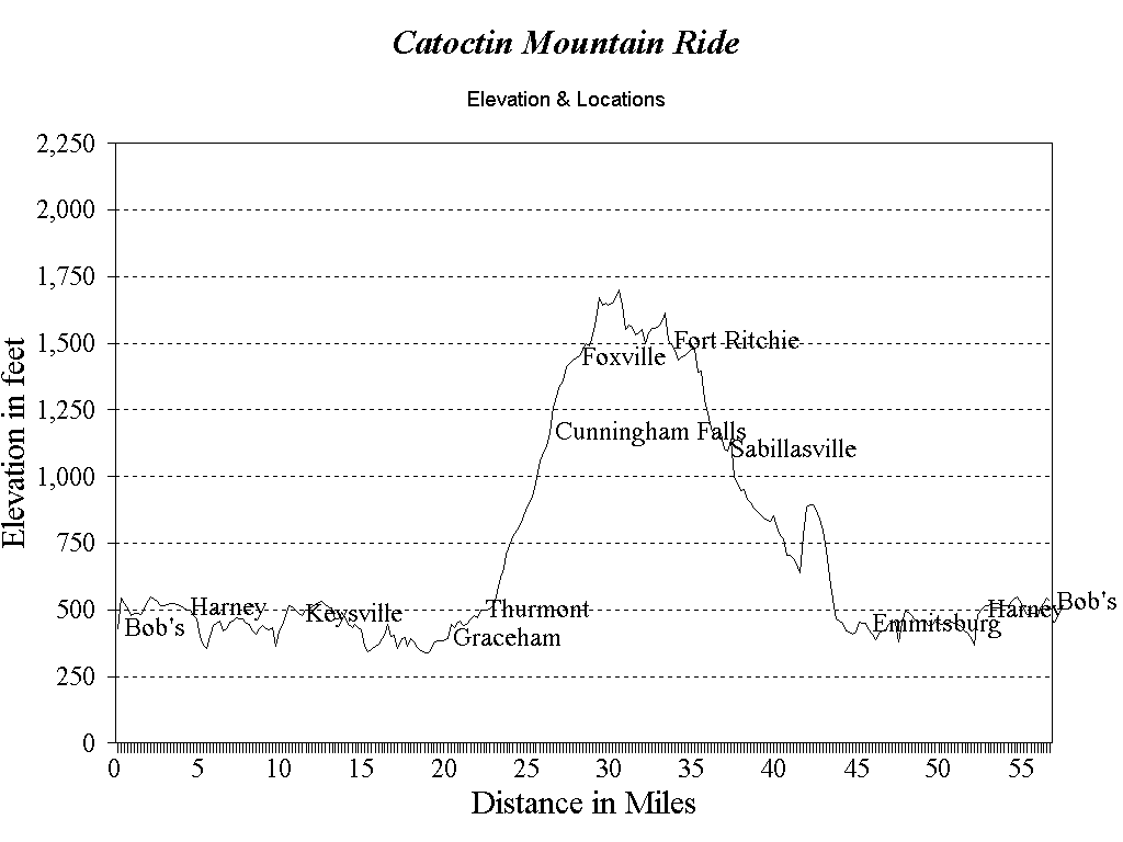
This was the first time I climbed this mountain on my bicycle and it was easier than I had anticipated. When it came to perspiring, Bob did plenty. Being frustrated from previous hikes with perspiration rolling down his face, Bob added a sweatband to his cycling attire. He was amazed how much difference it made with his visibility.
Having learned hard lessons from previous rides, I paid close attention to my calorie intake both before and during this ride. No way was I going to allow this metabolism ordeal to plague me during these training rides. This trip had us climbing over Catoctin Mountain just around lunchtime. A real test, perhaps, to find out if I could make it through a hike without gorging myself at the nearest corner store. Consequently, I stocked up double on the usual fare of raisins, bananas, etc. In addition to the food, I carried two bottles of water to keep myself hydrated. Bob had done this as well. When we reached the top, Bob and I turned onto a road that took us in a northwestern direction. We were in unknown territory and both of us thought we might have turned off one road too soon. Anyhow, it would be a few miles before Bob realized we were on the road that we were supposed to be on. He always had a penchant for getting us in the right direction.
Since Bob and I were on the ridge of the mountain and out of the protection of the trees, we were being whipped around by the wind. Unfortunately, it was this element that caused me to wreck my bike. I was riding the white line on a road with low shoulders. Suddenly, a gust of wind came from my left side and pushed me into the loose gravel. Before I could react, I went down. Unable to get my shoes out of my pedal clips quickly enough, I stayed with the bike on the way down. There must have been a curse on Bob and me that day with this pedal thing. Anyhow, my right arm took the brunt of the fall. Other than a scrape on my elbow and a dent in my pride, I managed to escape any serious injury. So I jumped up and took off to catch up to Bob. At this point, I remember passing a sign marking the Washington County line. I knew we were still somewhere in Maryland.
After being on the summit for quite sometime, Bob and I were ready for some downhill. Descending big mountains makes it worth the effort it takes to get to the top. There is some pretty country in the area through which we were riding. We savored the forty-mile per hour speeds down this hill. Descending this mountain was a white-knuckle experience. We enjoyed tucking ourselves into the smooth curves on this downhill. The centrifugal force from one bend eased our entry into the next bend. Looking ahead, we could see we had some more work cut out for us. Bob and I were entering another small mountain with a gravel road. It was, however, a relief to get away from our nemesis, the wind. The two of us made the ascent at an expected pace. Regarding our energy level and food supply, both of us were holding out really well. Planning my food supplies for this hike was a gamble but the guesswork paid off.
As Bob and I were working this climb, I was telling him of an article I had read about drinking milk shakes during rides to replenish carbohydrates. Therefore, knowing there was a McDonald's only a few miles away in Emmitsburg, Maryland, the thought of a milk shake was really whetting my appetite. I made a convincing point to Bob about the benefits of a mid-ride milk shake. He was a hard sale, but my persistence paid off with a chocolate milk shake. From McDonald's, we still had eleven miles to go to Bob's house. When we reached home, Bob and I had put in 56 miles for the day. We did the entire trip in three hours and fifty minutes. Our average speed was 14.61 mph. Bob and I felt a sense of achievement with this trip. The mountains, the wind, and the flats were a good mix. The most important accomplishment was that I made the distance without experiencing the "bonk." With two months remaining until our Betula trip there seemed to be ample time to train.
_______________
Nestled just north of Hanover are the Pigeon Hills. Bob and I planned much training for this area. By working these hills, we figured on enhancing our climbing and downhill skills immensely. The absence of any flats between the climbs made this area unique. As a bonus, working out in the shade of the trees was helpful. While the Pigeon Hills pale in comparison to the mountains we would be climbing during our Betula trip, it did provide us with a good training course. Saturday, April 22, 1995 at 10:30 A.M., Bob and I started our Pigeon Hill hike from my home on Boundary Avenue. We pedaled across Middle Street, than onto Moul Avenue. This flat run across town gave us the warm-up we needed to start the climbs. We rode on Fame Avenue to Youngs Road, then up Hershey Heights Road to Beaver Creek Road. These last three roads were gradual climbs until they reached the steepest hill in the area, High Rock Road.
Riding in the hills is fun because after the hard climbs we always had exciting descents coming our way. On the morning of this training hike, I tried something different for my breakfast. Cereal alone just had not cut it on previous rides. For this ride, I ate two bowls of Raisin Bran, a bowl of oatmeal, four pieces of toast and juice. This may seem excessive but my metabolism rate is high and I needed something that would power me for the hills. Bob and I planned to climb the Pigeon Hills eight times from all different directions. We did well at first and I remember telling Bob how strong I felt. Unusually strong. I convinced myself it was because of the morning meal.
As it turned out, that statement came back to haunt me a few hours later. Around the fourth or fifth climb, my energy level did a nosedive. I was flat. Luckily, Bob was holding up pretty well. Assuming we were going to have a short day, the only extra food I carried was a banana and a pack of raisins. I didn't feel it was necessary to pack a picnic lunch. My two bottles of Cytomax drink mixture were getting low.
Allow me to explain this Cytomax stuff. Bob had ordered this drink mix from a cycling catalog and my first impression was that it would be a cure-all. One has to be a rocket scientist to understand the ingredients. Alpha-L Polylactate is one such ingredient. What in the Sam Hill is that? This drink concoction increases your ability to buffer acid by 50% resulting in a 20% reduction in the level of fatigue you feel during training. Are you with me so far? On top of that, this mixture increases oxygen efficiency by 11%. No wonder I thought making paper airplanes in chemistry class was more exciting! I had visions of being eight feet tall and bulletproof drinking Cytomax.
3D view of the Pigeon Hill Ride near Hanover.
Bike route is highlighted in Yellow.
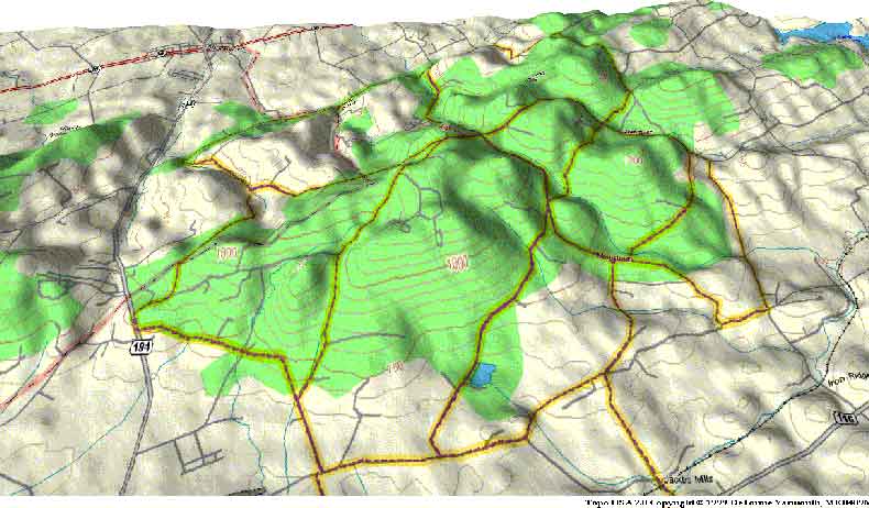
There I was, stuck in the hills with no food and no energy. Obviously, other factors needed to make Cytomax work. One of them was having enough food in me from the start. We aborted our plan to do eight climbs and exited the hills by way of Jacobs Mill Road. Bob and I headed toward Route 116 to get back to Hanover. As luck would have it, exiting the hills exposed us to the unwelcome wind. I concluded that today was not my day, much worse than having a bad helmet hair day. Bob and I managed to make it home to dump down some food. Our haggard appearance symbolized the kind of training ride we had. Naturally, I was disappointed in my effort for the day. The two of us rode a total of forty-five miles in almost four hours. A measly 13.5-mph average was the best we could accomplish. But not all was despair. I learned the hard way how important it is to combine good nutrition with exercise. For a workout in the Pigeon Hills, this was a starting point and there would be more experiences like these.
While I was figuring out the right combination for my nutritional needs, Bob had a monkey on his back, also. During the first few weeks of training, Bob would work up quite a sweat. While we would be resting at the end of our hikes, this sweat would dry and leave a white residue on his face. It looked like someone threw powder at his face. We figured it was the sodium washing out of his system. Things were really looking up when Bob's face did not have white scale on it and when I went the distance without starving.
_________________
Looking through our training diaries, Bob and I noticed that we had cycled only about five hundred fifty miles in the four months of training thus far. All of this mileage was an accumulation of smaller hikes. These hikes were good for us, but it was time to start doing single day hundred mile trips, better known as century rides. Realizing that our Betula trip would be long and mountainous, we mapped out a route that would combine both elements for a training ride. Psychologically, we needed to do a century ride. On Saturday, May 20, 1995, we embarked on such a trip. Bob had been on a century ride a few years earlier while this was an inaugural event for me.
We drove my truck to our starting point at a church parking lot two miles north of Carlisle on Route 74. It was about 8:30 A.M. when we started our ride. From where we parked, Bob and I had a five-mile warm-up to our first climb of the day, Waggoners Gap. From a distance, this mountain is an intimidating sight. Upon reaching it, the severity of the incline hit us like a brick wall. However, we did not let it overwhelm us. Bob and I were not quite sure of a strategy to use for this climb so we gave it a mixed bag. We rode conservatively a little, then we would stand up and pedal hard for short distances. This made the hike to the top go fast. Before long, I crested the summit with Bob just behind me.
The descent allowed us to reach speeds up to 40 mph. We honed our skills on handling the sharp hairpin turns better known as switchbacks. The two of us went into that mountain enthusiastically and came out unscathed. Bob and I continued along Route 74 for three miles and made a left turn onto Route 274. We were headed toward the western part of Perry County. Bob's itinerary included stops for twelve covered bridges, but after the first bridge I was more interested in training than in touring. My thoughts were primarily on the hundred-mile ride and nothing else.
We cycled through the small towns of Andersonburg, Blain and New Germantown. Surrounded by hills, Bob and I really enjoyed this area. Straight ahead in the distance we could see two mountains eventually combine to provide us with our second major climb of the day. No story about cycling could be complete without the proverbial dog chase. I came close to having souvenir bite marks on my calves, while approaching this mountain. I was passing by a home when suddenly a dog from nowhere made his charge. Identifying the canine as a Doberman was enough to adrenalize my legs. Either the staring him down or the yelling distracted the dog enough to give me the edge I needed to get out in front. Bob gets a lot less disturbed about these ordeals than I do. As a benefit from this experience, I got some good practice at sprinting.
After a few miles of riding level ground, Bob and I started our second major climb. The name of this mountain was Big Springs. This was the longest mountain I have ever climbed. I went through plenty of water during this ascent. When I reached the top, there was not a drop of water left in either of my bottles. This made me uncomfortable. Besides, I believed it only made me thirstier thinking about it. As a result, I learned that one can squander away essentials quickly on a mountain of this caliber.
Reaching the summit, I was far enough ahead of Bob that I could not even see him. Again, I broke the cardinal rule of team cycling - "never lose sight of your partner!" At the top of the mountain was a sign that said I was 1806 feet above sea level. I started my descent. Ah, the downhill runs! I was like a kid in a candy store. This road was fantastic because it was straight with no switchbacks. With speeds up to 45 mph, this was another white-knuckle experience. Thank goodness I had my new cycling shades on to keep the wind out of my eyes. During earlier training rides when I had only my prescription glasses, the wind often whipped around the lenses and made my eyes water so much that I could hardly see. This made it impossible to keep focused on the roadway.
After two or three miles of descent, the road began to level off. I was passing a few houses when I noticed some folks relaxing on their front porch. Here was my opportunity to refill my empty bottles. These kind people were much obliged to cure my thirst. They offered me water from the well in their back yard. This well, with an archaic hand pump, confirmed my suspicions that we were in Appalachia country. Of all my travels on my bike, the water from that well was the best I ever tasted.
A few minutes had lapsed before Bob flew by. I yelled to get his attention, figuring he was in need of water also. These hospitable folks were in awe at what Bob and I were planning to accomplish that day. After telling them where we were going, they looked amazed because they were not even sure their pickup truck could go that far! They were really shocked when they seen Bob's clipless pedal system. These folks quickly concluded that Bob and I were nuts. I think they are right! Anyhow, we were grateful to them and figured we better continue our journey so we could keep our schedule.
We went a short distance before turning eastward onto Route 75. This freshly paved road with wide shoulders is a cyclist's dream. Bob and I were on top of our game with this road. With these premium road conditions, we honed our drafting skills tremendously. We reached a town called Honey Grove and headed north on Route 850 toward Reed's Gap. After a mile or two, we came to Route 35 where we again turned eastward toward Mifflintown.
While on this road, Bob was still blazing a trail. Unfortunately, I was starting to feel a bit drained. There must be a way to overcome my fatigue during these rides. With the two hundred five-mile ride coming up soon, I had to find an answer. As a temporary remedy, I took it easy for a few miles. Route 333 was our next turnoff and then we had only about four miles until we reached Port Royal. We could probably refuel at the Uni-Mart convenience store located on the side of town where we would enter. Hunger was getting the best of me. Having already put in sixty miles for the day, it was all I could do to get to that food stop. We finally made it. Normally, I am careful not to overindulge myself while cycling big trips. As starved as I was, I threw common sense to the wind. My lunch meal consisted of Gatorade, milk, bananas, a hot dog, cupcakes and sunflower seeds. Bob had his fair share of the "munchies" as well.
With two big mountains to climb yet on this trip, I knew I had to load up on the food. This option came with no guarantee but I knew my success was marginal without it. At this point, we were feeling a bit tired and it was starting to get hot. The time was 1:30 P.M. After our banquet, Bob and I mounted the bikes and headed west on Route 75. A few miles later we were turning south onto Route 74 and staring at the steepest mountain of the day, the Tuscarora. This mountain is the granddaddy of them all. We had to conquer this hill for two reasons. The first reason is to familiarize ourselves with a climb of this magnitude. During our upcoming Betula trip, Bob and I would be at the one hundred forty-mile mark when we would get to this point. So it was crucial to learn this mountain inside and out. Second, the two of us had to get over it to make it home!
The Tuscarora is a long, steep mountain with three switchbacks. A three and one-half mile climb from the bottom to the top was awaiting us. Bob and I had no preconceived plan for it. Call it hands-on-training. Away we went. The higher we climbed, the higher the temperature rose. This ascent was a test of willpower. We almost relinquished about two-thirds of the way up when we stopped for a quick respite from the heat. Both of us were thinking of our health at this precise moment. After a few minutes of rest, Bob and I went on to the top. It was a great feeling to reach the summit. This huge mountain we rode often by car actually had fallen victim to our bikes. We could now call this mountain ours!
Bob and I were on a roll. After mastering the big one, we quickly got into our descent mode. Both of us anticipated fast speeds and sharp turns. And we got them! The speeding descent carried us a few miles down the road into the town of Ickesburg, Pennsylvania. During this part of the trip I felt really strong. I was really putting the hammer down. Bob was not so lucky. He lost his energy shortly after the Tuscarora. His situation was similar to the experience I had earlier in the day on Route 35. I was confident that he would recover, and eventually he did. The road between the mountains was flat, enabling us to stockpile some energy for the next climb, Waggoners Gap.
An hour and fifteen minutes later we were at the base of Waggoners Gap. The two of us were no longer rookies on the Gap since we had already climbed it once. Simply put, it was everything in reverse only eight hours later. Bob made an excellent recovery just in time for the ascent. I was more than half way up the mountain when I noticed my rear tire was flat. Climbing at only 5 mph, I would not have noticed it if I had not looked down. I disregarded the flat tire and continued climbing. When Bob and I reached the top, we attempted to pump air into my tire. No luck! Ah, the heck with it! I'll go as far as I can the way it is! Besides, we had only seven miles to go.
The challenging part was that I still had the downhill run coming to me. Bob, like usual, got the jump on me and was blazing down the mountain. While I could not enjoy the rocket pace he set, I did manage a respectable 35-mph out of it. The vibration and wobbling made it necessary for me to hold tight the whole way down the hill. Keeping the tire centered on the rim was tedious. This forced me to stay straight up on my bike as much as possible. Aerodynamics was no longer an option. A few miles later Bob and I reached the church parking lot where we had started that morning.
We had done it! Bob and I cycled one hundred twelve miles over five steep mountains in eight hours and fifty-seven minutes. We were both tired, hungry, and hot. What we learned that day was invaluable toward helping us achieve our goal of two hundred five miles in one day. The strategies we had used today were successful, especially the mountain climbing techniques. Positive thinking saved us in a few clutch situations. Bob and I knew we could better ourselves even more on our next century ride. The Betula trip was only a month away and things were finally starting to come together.
__________________
Three weeks after our first century ride, Bob and I were ready to tackle our second hundred-mile ride. During that period we continued to work the flats and the Pigeon Hills. It was imperative that we maintain our condition to succeed at this second century ride. Saturday, June 10, 1995, we again put ourselves to the challenge. The weather forecast that morning was not too promising. From the time I left my house in Hanover and arrived at Bob's house in Littlestown, the precipitation was becoming substantial. Bob and I thought the rain would eventually subside. We soon found out otherwise.
We took off around 7:15 A.M. toward Gettysburg. As we approached this historic town, the roads were considerably wet and so were we. Bob and I worked our way toward Biglerville where we passed through a small shower. Now we were thoroughly soaked to the point we had puddles inside our shoes. Had either of us suggested aborting, there would not have been any opposition. Luckily for us, neither revealed his intentions. Simply, there was no turning back on this one. Our theory was that the rain might be something we would have to deal with on our Betula trip. We meandered through Bendersville and on up through Michaux State Forest. The ascent up Michaux was much quicker than the last time we did it in March. Experience and motivation were our allies.
The wet roads put a damper on the much-anticipated downhill run. An incident on the descent almost ended Bob's ride for the day. Approaching a very sharp curve with considerable speed, Bob's brakes were not fully functional due to wetness on his rims. He found himself going through high grass on the opposite side of the road. Skill was the only thing that kept him on two wheels. It is unbelievable, how he managed to escape that one. Once we came down that mountain, Bob and I immediately climbed over the hill at Pine Grove Furnace. An unexpected reprieve came our way as the rain stopped momentarily. So far, both of us were riding really strongly for the day. After descending Pine Grove, Bob and I were on our way to Newville, Pennsylvania in northern Cumberland County. This ten-mile stretch of highway was an excellent window of opportunity for us. Here was a chance to improve our drafting skills. Surely this would benefit us during the upcoming Betula trip.
Passing through Newville, Bob and I were closing in on our next mountain, Doubling Gap. Neither of us had ever been in this area before, thus making it even more exciting. As luck would have it, the precipitation was making its presence known again. The mist was coming down as heavy as it could before crossing the threshold where it was a steady rain. It was not until we started climbing the mountain that we realized how steep Doubling Gap was. The low visibility hindered us from seeing far enough ahead to get a feel for the altitude. During our slow journey toward the summit, Bob and I were encouraging each other to keep the pace. The two of us cited the story of The Little Engine That Could as an inspiration. I think I can! I think I can! We could not quite sense how high we were in comparison with the surrounding hills, because the fog was really thick in the upper reaches of this mountain.
Having reached the summit, we were forced again to descend cautiously due to the wet roads. Bob and I rode approximately five miles until we reached the town of Landisville. Here we afforded ourselves the opportunity to grab a quick snack. We were both drenched! Our shoes were heavy as bricks from all the water that they had soaked up. After a brief rest, we headed east on Route 850 toward our next road, Route 74. This road was familiar since Bob and I had previously cycled it during our first century ride. The only difference was on that particular day we were dry and today we were drenched. Surely, the two of us did not have a worry in the world about overheating. There were times when I even got a chill. During my entire biking career it was rare when I got goose bumps while riding.
Bob and I were only three miles from Waggoners Gap. This was the third time within a month that we climbed this mountain. The continual climbing simply reassured us of our cycling worth. Pedaling up these mountains does wonders for a cyclist's morale. Again, we experienced a wet ride up one side and down the other side of Waggoners Gap. Thanks to Mother Nature, there were no breathtaking speeds on the wet and slippery downhill run this time around. On top of that, the rainy weather caused my cyclecomputer to go on the blink. Everything would be guesswork from here to the end of our ride. Bob and I continued into Carlisle and on to Mt. Holly Springs.
The two of us traveled south on Route 34 toward Table Rock to Hunterstown. Then we crossed Route 30 to Centennial Road and started taking back roads to reach home. Pedaling through Brushtown I became sluggish. Bob and I had one hundred ten miles in for the day so far. We were wet, hungry and tired. I was just dragging along these last few miles until we reached Bob's house on Teeter Road outside Littlestown. The numbers said it all. These boys pounded out one hundred seventeen miles over six mountains in eight hours and fourteen minutes. Our average speed was 14.24 mph with a top speed of 43 mph. Considering the weather we fought all day, we were more than a little pleased. We were both extremely satisfied with our effort for the day. Bob and I had each labored at times, but were steadfast in our determination not to deviate from our goal.
The Betula trip was only two weeks away. In the past four months, Bob and I had trained hard and had learned many valuable lessons. Both of us felt we had done all that we could physically, emotionally and mentally do to prepare for the big day. Within the course of the next fourteen days, I rode another eighty miles to keep myself limber. Our primary focus at this point was on our diet. Bob and I began to load up on carbohydrates. Our mandate was to cover every facet of the Betula trip. We went through every detail with a fine tooth comb. Remembering the Boy Scout motto "Be prepared," Bob and I applied this wisdom to the monumental task of preparing for the Betula trip.
The wheels were in motion. After months of serious training, Bob and I had that one final item to take care of, securing a support team. This final detail would be crucial to the success of our cycling extravaganza. My brother, Mark, and Bob's brother, Ken, agreed to be the team we needed. Bob and I stressed how important their role in this trip would be. Ken and Mark were as much a critical part of this team as the cyclists themselves. In brief, they would be our lifelines. Bob and I were in prime condition and we were eager for June 24, 1995 to arrive.
__________
The weekend of our Betula trip was finally here. Around noon on Friday, June 23, 1995, Bob arrived at my house to pack up the gear into the Isuzu Trooper and do some final preparations. Forty-five minutes later, Bob's brother, Ken, met us. The three of us went out to Mark's house in Edge Grove to pick him up. Around 1:15 P.M., the riders and the support crew began the northward trek toward the mountains. We traveled through light rain the whole way to Lewistown before clear skies prevailed.
We stopped for dinner at the Mt. Nittany Inn, at the summit north of Centre Hall, Pennsylvania. This was our final carbohydrate-loading meal before the big day. Pasta was the obvious choice for dinner. After an hour of fine dining and hearty conversation, it was time to get the show on the road. At various points along the way, Bob and I discussed some battle plans for the next day, such as hill climbing techniques, aerobar usage, descent strategies, etc. Unfamiliar with the technical jargon, Ken and Mark's single question was, "Do you think it can be done?" Bob and I responded, "We're optimistic, we'll have to wait and see."
As previously planned, we stopped at the top of Wykoff Run. This winding road is a picturesque route that cuts through the lush mountains of Elk State Forest in Cameron County. Much to Ken's liking, this path runs parallel with a wonderful trout stream. Bob and I wanted to ride nine and a half miles on this road. There were plenty of thrills in this downhill run. To record this event, Bob equipped himself with a "head cam." You guessed it, a video camera mounted on top of his bicycle helmet. We created some great shots with the video recorder. This short ride was what I needed to put me over the 1,000 mile training mark since mid-February. Wykoff Run gave us some really impressive statistics. Our speed averaged out to 26 mph over the distance of 9.27 miles. My maximum speed was 39.5 mph, while Bob reached close to 43 mph on his bike. Our total time to accomplish this segment was 20.21 minutes. This was a fun and relaxing ride, a primer, you might say, to set the tone for the next day's ride. So we packed everything back into the Trooper and were on our way again.
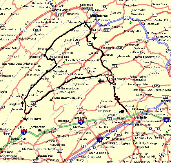
Our final destination, Betula, was only thirty-seven miles away. Betula is a small village nestled off Route 46 between Emporium and Smethport, Pennsylvania. Once a bustling lumbering town in the early 1900's, this area is now home to a few dozen hunting camps and homes. Very little remains as a witness to the industry that built this town. It is well worth the drive to see the mountains in this area. We finally arrived in Betula around 8:15 P.M. The four of us wanted to get everything ready for the next day and still attain a reasonable amount of sleep. We watched our Wykoff Run video and went through Saturday's itinerary with the support crew.
I slept well that night, only to have the alarm clock go off at 4:25 A.M. Never being a morning person, I was dragging around at first. Bob can relate to this condition also. First on the agenda was breakfast. I went with a meal that had been successful for me in the past. My jump start breakfast consisted of two pieces of jelly toast, three bowls of raisin bran, a bowl of oatmeal, orange juice, and a banana. Honestly, after eating all that food, I did not feel stuffed. I was confident that it would carry me a long way into the ride. Bob ate three bowls of Cocoa Krispies to delight his palate. As Bob and I were eating our breakfast, we heard thunder off in the distance. We looked at each other with an unfocused gaze. The last thing we wanted to do was ride through thunderstorms.
Immediately after breakfast, I got dressed in my cycling outfit and filled the rear pockets on my jersey with Power Bars, Snack Wells, raisins and a banana. Besides the food, I prepared two bottles to carry on my bike, one with water and the other with Cytomax. I thought this would sustain me at least until I reached the Sinnemahoning Bridge, which would be approximately thirty-seven miles into the trip. There, Bob and I would replenish our bottles with the water that we had dropped off the previous night. The support crew planned on meeting us at mile mark 46 on the Quehanna Highway. We woke Ken and Mark around 5:00 A.M. With some rushing around, we embarked on our journey at 5:18 A.M., three minutes later than planned.
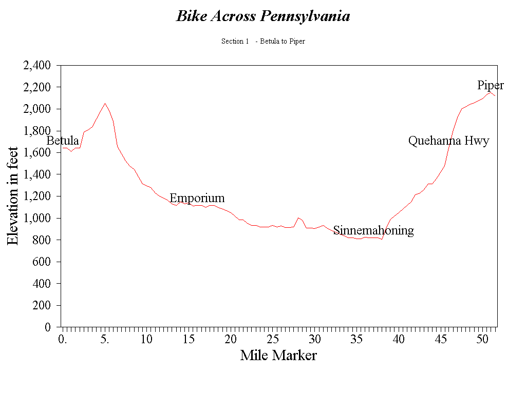
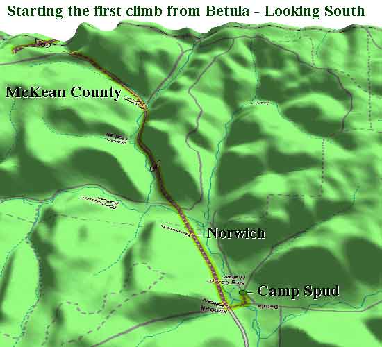
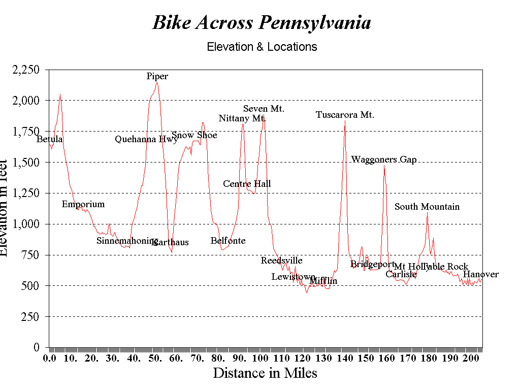
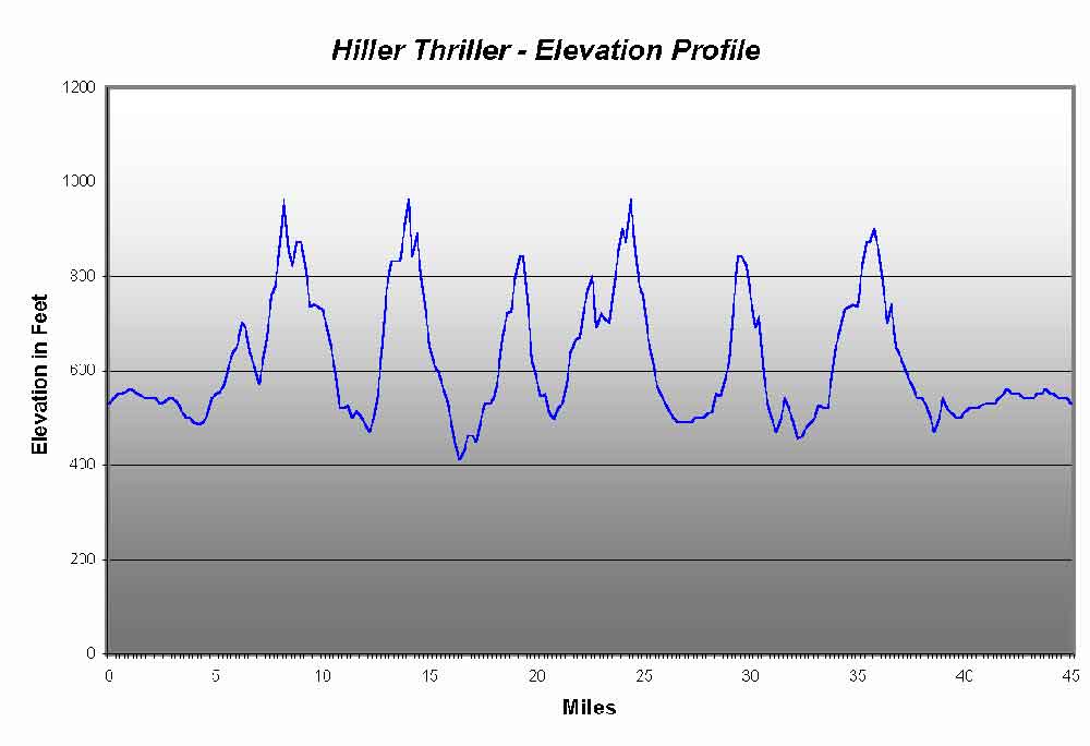
Our support team gave us a sendoff with wishes of good luck. The sky was turning just light enough to see the roadway. We were under cloudy conditions with a light mist and the temperature was a comfortable sixty-three degrees. In less than a mile, Bob and I were on Route 46 and close to the first of eight mountains we planned to conquer that day. We breezed through the area known as Norwich. It was a booming town supported by intense logging operations. Today, no houses remain. We began the climb and the sound of our bikes on the wet road kicked out a few deer. One truck passed us and before we knew it, we were at the top of the mountain at 2,050 feet.
We descended conservatively in comparison to the usual breakneck speeds we experienced during our training rides. It was just too early in the trip to be foolishly wasting energy on this downhill run. Anyhow, for the first sixteen miles we did manage a respectable 21.33-mph average. Reaching the town of Emporium, Bob and I were four minutes ahead of the schedule card. All systems were going well. During our training rides, it normally took five to ten miles before I was warmed up and past the winded stage. The bizarre thing about the early part of this trip was that I did not go through the phase of being winded. I felt relaxed and comfortable and this was a great psychological boost.
The streets of Emporium were bare when we went through around 6:03 A.M. Emporium is the county seat of Cameron County. This little town with a population of twenty-five hundred has garnished itself with the title "Tree City, U.S.A." We were on our way and I remember telling Bob "We only had one-hundred and eighty-nine miles to go." Our next segment was a twenty-two mile stretch to Sinnemahoning. We did not anticipate any problems along Route 120 because we were dropping four hundred feet in elevation from Emporium to Sinnemahoning. There was not much shoulder on this road, but with the lack of traffic that was of no concern to us. As we passed the Emporium Country Club, about nine miles east of Emporium, it started misting. This picked up considerably until we got close to Driftwood, four miles from Sinnemahoning. At this point, the mist became a genuine downpour. Within minutes, we looked like drowned cats. Our shoes and socks were soaked. The rain lasted only about three miles, but it seemed like forever. As we reached Sinnemahoning, the shower stopped momentarily. The time was 7:13 A.M.
Crossing the bridge, we quickly realized we had to use extreme caution. The rain on the bridge made the metal grating very slippery. When both of us reached the other side, we topped off our bottles with the water we had set aside the night before. Bob and I were one minute and fifty-eight seconds behind our scheduled time after taking this three-minute break.
Climbing Wykoff Run to take on our second mountain, the rain started again. This downpour lasted only a few miles. The tranquility in this area was greatly appreciated, knowing the further south we headed, the more competition we would have from other vehicles on the road. We averaged 12.12 mph up this ten-mile climb to the Quehanna highway. Bob and I gained a whole sixteen seconds on that ascent. This micro-management of time was evidence of how disciplined we were to a strict and well-planned schedule.
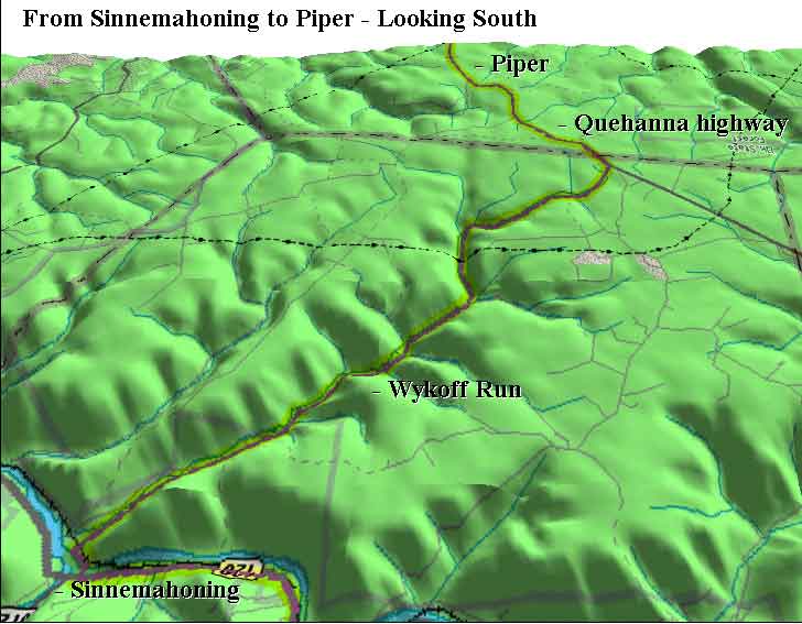
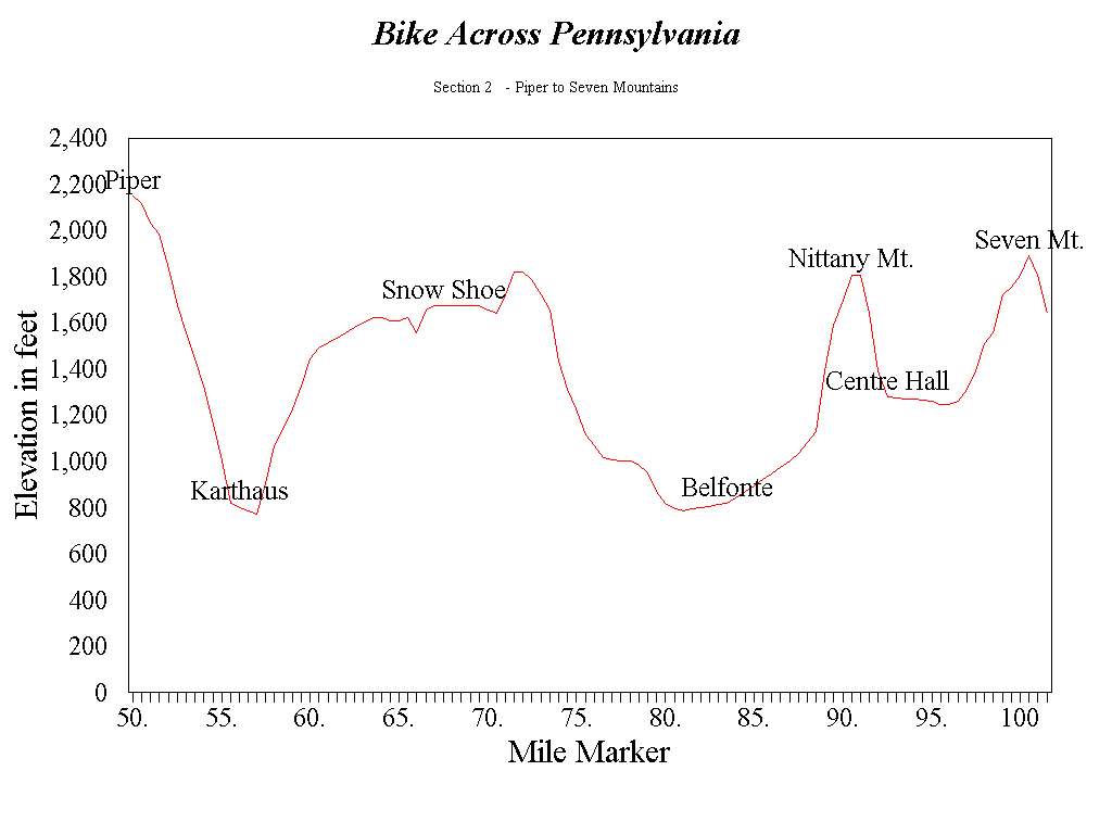
We had planned our first rendezvous with our support team at the top of Wykoff Run. Upon reaching it, there was no sign of them anywhere. It was imperative that we continue, so Bob and I rode four more miles to our highest point in elevation on our trip, Piper. Located in Clearfield County, this town, was in the third county we rode in so far today. The two of us were now 2,148 feet above sea level. Piper was once the site of a secret military research area associated with the Manhattan Project. The area is currently home to a prisoner boot camp and a PennDot training center. We took a quick break to try to contact our support team via our cellular phone. No luck. Bob and I used this stop to track our progress and to take some aspirin. The medicine was a preventive measure for any upcoming pain we would encounter as the day went on. Well, it was time to roll again.
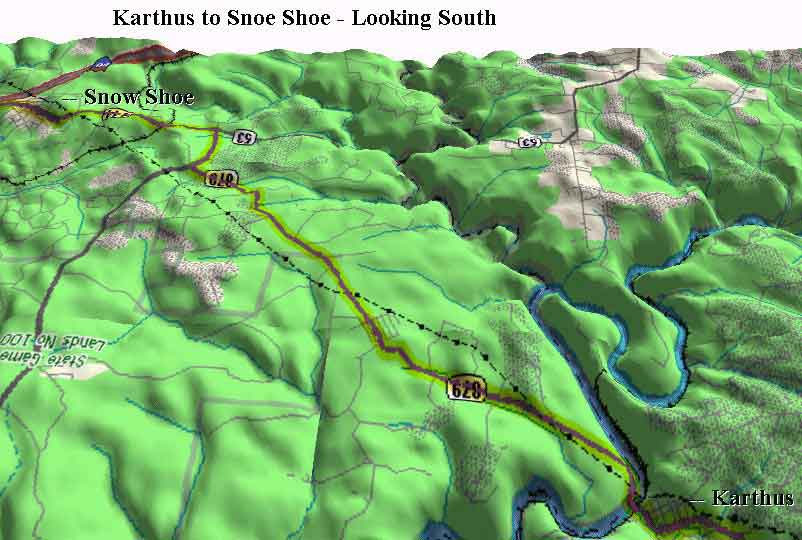
Next up was a cyclist's dream. Imagine, five miles of straight downhill. Bob and I had been waiting for a long time to do this one. The two of us reached speeds in the mid 40's on this hill. This helped us to dry out from the rain we encountered earlier in the morning. At the bottom of the hill, we turned left onto Route 879 and entered the town of Karthaus. Our third mountain of the day began as we crossed the west branch of the Susquehanna River on the other side of town. This climb was similar to Wykoff Run in that it was long but not steep. As we were ascending this mountain, Ken and Mark finally caught up to us. No harm done though because we were surviving so far without them. Bob and I restocked with food and fluids, which sustained us until we reached the apex of this mountain. Twelve miles and sixty minutes later, we reached the apex at Snowshoe, Pennsylvania. One third of the entire trip was completed.
Sixty-nine miles of pedaling were under our belt. Bob and I were pumped for some heavy duty cycling.
We stopped briefly at Snowshoe for some food other than what we were carrying. Eating apple sauce without spoons and gulping down milk was our specialty for this stop. Looking at the clock, the two of us were four minutes behind schedule and we felt really good so far, but there was plenty of work to be done. Before leaving we chose Bellefonte as the next town to meet with our support crew. Immediately after our five-minute break, Bob and I continued south on Route 144. This road runs on the north side of Interstate 80 then crosses and runs parallel with it to the south. Route 144 was strategically chosen when we planned our itinerary. Most of this road is shady, which would have provided us relief in case it had been sunny. Lucky for us, the skies were overcast, which was ideal. We even managed to go a few hours without getting soaked as we did at Driftwood and Wykoff Run.
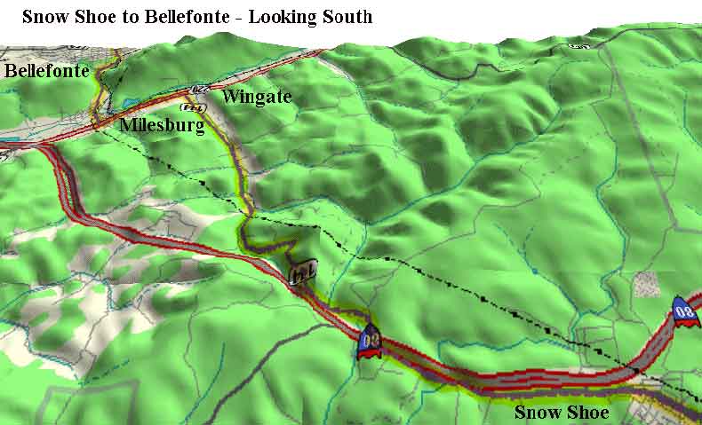
When we got on the south side of I-80, the descent carried us the whole way into the town of Wingate. Shortly afterward, we passed through Milesburg in a blink of an eye. Before Bob and I knew it, we were in Bellefonte. From Snowshoe, our average speed for the sixteen mile segment was an amazing 20.21 mph average. Built on several hills at the base of Bald Eagle Mountain, Bellefonte's name comes from its "beautiful fountain," the spring that furnishes the town's water supply. Known as the "Home of Governors," seven of the town's residents have become governors of Pennsylvania and other states. Many of Bellefonte's homes are fine examples of early Georgian architecture. Quickly, I realized that I'd better concentrate on the task at hand and save the sightseeing for another time. Outside Bellefonte, Mark and Ken were patiently waiting for us. The first thing on the agenda at this stop was to get into dry socks. After the five and a half-hour ride so far, my feet were uncomfortable from being wet. Changing into dry socks was a real blessing. Secondly, riding through the rain and picking up road dirt made it necessary for me to oil my chain. What a difference the little things did for a ride like this! Again, we replenished our food and drink supplies. The time was 10:43 A.M. and Bob and I were two minutes behind schedule.
Before we left Bellefonte, we arranged with our support team to call Deb Schuman in Reedsville to tell her what time we would meet her there. Earlier in the week, Deb, my neighbor, told me she was going to be at her camp near Reedsville that weekend. This town is the halfway mark of the total ride. Since Bob and I would be going through there around lunchtime, this would be an opportune time to grab some lunch. So we arranged ahead of time for this important stop. All that was needed was a phone call to let Deb know when the cyclists would be there. After Bellefonte, we rode toward our fourth mountain of the day, Pleasant Gap. Incline and length defined this climb. Using the lowest gears of my bicycle was very effective on this hill. I had considerably lower gears than Bob, so uphill climbs were no problem for me. On the other hand, Bob's higher gears enabled him to overtake me on the downhill runs. Which he did!
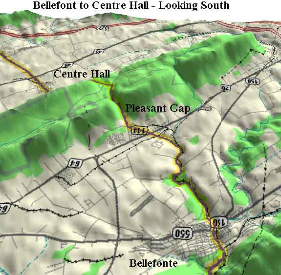
The ascent up Pleasant Gap was challenging not so much for the climb but for the traffic. For the first time on this trip we had to contend with a high volume of traffic. At times it was a really harrowing experience on a narrow shouldered road such as this one. I crested the hill around 11:30 A.M. and waited three minutes for Bob to catch up. He seemed to be struggling a bit since our stop at Bellefonte. The two of us then began our descent into Centre Hall. This was another forty some miles per hour downhill run. Unfortunately, the heavy traffic in town reduced our momentum. There was a street fair taking place that weekend. We continued riding another half mile to the traffic light at Old Fort. Here, Bob fell off his bike while trying to disconnect from his clipless pedals. This was the second time that this had happened this year. The first time was when we were cycling through Thurmont, Maryland. During that training ride, I dropped my water bottle in the center of town. Bob braked suddenly to avoid a collision. Unable to get his shoe out of the clipless pedals quickly enough, he wound up lying in the middle of a busy street. Here at Old Fort, I tried to make light of the situation. I told Bob he should have at least waited until I threw my water bottle in front of him before he decided to entertain the masses with his fall.
Bob cut his left knee and luckily for him Ken and Mark were at the intersection when it happened. Bob and I were fortunate to have them as our support team. Their efforts did not go unnoticed. Ken and Mark administered some first aid to Bob's knee and we were on our way again. The two of us rode five miles of level terrain on Route 144 before passing through Potter's Mills and then onto our fifth mountain of the day, Seven Mountains. We were now heading south on Route 322. At this point, we entered Mifflin County. This was the fifth of ten counties we would be passing through during this hike.
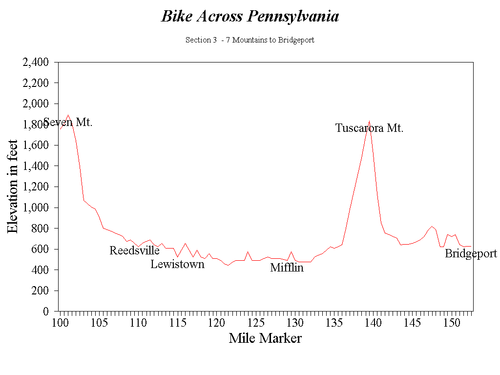
The rain started again and continued the whole way until we reached the south side of Seven Mountains. This climb was great because we had smooth road surface and wide shoulders. Finally, after reaching the top, came the fun part of descending the mountain. The time was 12:17 P.M. and we were five minutes ahead of schedule. Despite the rain, Bob and I achieved our fastest speed of the day descending Seven Mountains. The 48-mph downhill run gave us the momentum we needed to carry us the whole way into Milroy. There was plenty of competition with the traffic on this road. Besides the cars and trucks whizzing by, Bob and I carefully avoided the mounds of cinders lying on the roadside from the previous winter as the rain and spray from the cars pelted us. Talk about life on the edge! We even passed Ken and Mark, who were eating lunch at an Italian restaurant. These men earned it. They were putting in a good day's work, too!
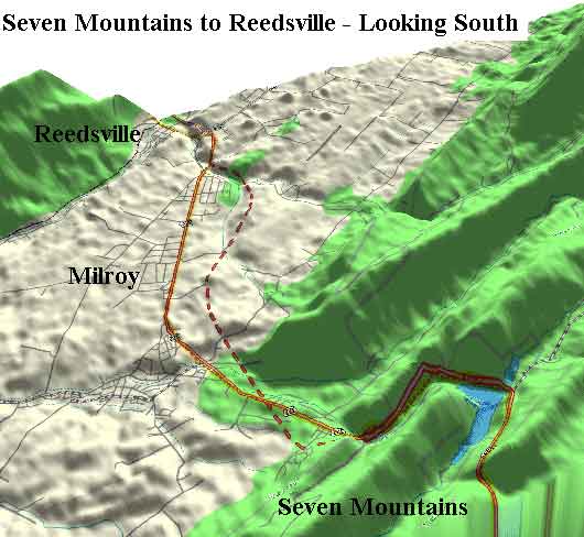
South of Milroy, Route 322 becomes four lanes. That meant, of course, no bikes allowed on that highway. We detoured at the Reedsville exit onto a road better known as the old Route 322. In a few more miles, Bob and I would be having lunch. Upon reaching Reedsville, we already had seven and a half hours on the bikes for a total so far of one hundred ten miles. The last nine miles had gone very fast. Since cresting Seven Mountains, that calculates to an average speed of 25.5 mph. The two of us still felt strong at this stage of the trip. A few minutes later, Deb arrived with our lunch. She had brought us warmed-up ravioli and water. Eating lunch took another ten minutes off the clock.
Time was wasting and we had to get the show on the road. That stop put us eighteen minutes behind the schedule card. The time was 1:02 P.M., so away we went! Bob and I quickly pedaled through the towns of Burnham, Yeagertown and Lewistown. These towns were pretty close to each other, so we really did not notice when we were through one town and into the next. From an altitude standpoint, Lewistown was the lowest point of our trip at four hundred ninety-five feet above sea level. After Lewistown, we rode south on Route 103, crossed the Juniata River, and then onto Route 333. Here, we rode eastward for about twelve miles on a road that ran parallel with Route 322, which was now to our left.
As Bob and I meandered our way along Route 333 through Mifflintown, our pace slowed considerably. During a short break, we discussed our pace and the time we lost back in Reedsville. We lost a few more minutes to the schedule although this segment seemed to take forever. We were not too concerned about the change of pace at this point. The remainder of the trip would be on roads with which we were familiar. Bob and I could adjust accordingly because we knew what to anticipate and how to pace ourselves for the remaining three mountains. We were on the road again now twenty-thee minutes behind schedule. As we reached Port Royal, we turned west onto Route 75. Along this road for the next four miles, Bob and I gazed to our left and glimpsed the steepest mountain of the entire trip. The name of the mountain is Tuscarora.
With the upper portion of the mountain shrouded in thick fog, we figured another soaking was inevitable. After a brief stint on Route 75, we turned south onto Route 74. There was less than a mile and a half to the big one. Bob and I met with our support team at the base of the Tuscarora to top off our drink and food supplies. We told Ken and Mark to wait for us at the top. Cycling one hundred and thirty-five miles so far, Bob and I were due for a reality check. Factoring in the steepness and weather conditions, both of us estimated it would take close to an hour to reach the summit. We were already twenty-seven minutes behind schedule. Again, we were on our way! I put myself into a conservative mode right from the start. This seemed slow at first, but we it was a consistent pace and I was not short on breath during the climb.
Somewhere between the first and second switchbacks, I lost sight of Bob. The weather was foggy and drizzly, but I was confident he was back there somewhere. I continued ascending at the pace I started with. I often thought that climbs like these are much easier the second time around. Bob and I had climbed this mountain during one of our training rides. Perhaps the fog was a blessing in disguise. Unable to see how far it was to the top, it would be a surprise when we reached it. Sure enough, before I knew it, I was there. The amazing part was that I made the 1200 feet, three and half mile climb in thirty-three minutes. After reaching the summit, I got off my bike and rested for three minutes until Bob reached the top. Out of curiosity, I checked my pulse. At ninety beats per minute, I realized I was in better shape than I thought. Our average speed ascending was 6.36 mph. The two of us gained twenty-six minutes with this incredible climb. This put us fifty-four seconds ahead of schedule. There was hardly a better way to accent our hike than to shred mountains up like this.
Again, Bob and I realized that our descent could not be as fast as we would have liked due to the wet roads and fog. The Tuscarora Mountains were history. After our descent, we went through the town of Ickesburg. I still felt good, but how quickly things change. From out of nowhere, I went flat. Not the bike, but me! Hunger was not a factor that I could tell. God knows I had my fill of Snack Wells and Cytomax all day. After awhile, these items start to grow on you. I think fatigue got the best of me. My eyes wanted to close so badly, I thought I was falling asleep riding my bicycle. The word struggle best describes my dilemma for the next sixteen miles. I was merely doing ten miles per hour at best. Ken and Mark were miles ahead waiting for us at Waggoners Gap, so any sort of rescue effort was moot at this point.
Physically, this boy was scraping the barrel. I knew I had to win this one mentally. If I stopped, I would be finished. No matter how slow it seemed, I kept pedaling. Bob was way out ahead of me. At times, I could not even see him. This had occurred several times during our training rides, so there was no need for alarm. Sometimes it would be Bob, who would be the slacker and sometimes it would be I. Unfortunately, I really did not need this to be happening in the middle of a major hike. Two miles before Waggoners Gap, Bob slowed down to allow me to catch up to him. I took advantage of some well-needed drafting support, which was enough to keep my head above water for now. Finally, we caught up with Mark and Ken at the base of Waggoners Gap. What a relief it was to see them!
The thought of a comfortable bed in a Carlisle hotel was real tempting, but aborting at this stage was not an option. I immediately got off my bike and sat in the vehicle. Being so tired, I could not even think straight. Sitting and closing my eyes for a quick rest, Ken noticed right away that it did not look good. Meanwhile, Bob and Mark were entertaining themselves trying to get Bob's shoe disconnected from his pedal. Not until Bob took his foot out of the shoe were they able to succeed. A loose screw in his cleat turned out to be the culprit. This loose foot cleat was probably the reason Bob fell earlier at Centre Hall. Speaking of loose screws, I was beginning to wonder what this trip was all about. I surrendered to the fact that we lost much precious time the last fifteen miles. Finally, it dawned on me the longer I sat in that truck the less time we would have to finish.
While hunger still was not a factor, I did have a craving for a cupcake. I ate my cupcake at the same pace I had ridden the last sixteen miles, slow. The support team suggested that I change into dry socks and shoes. For my feet, it was like night and day. This was the beginning of my comeback. Starting to show some signs of life, it was then that I knew I had to pull out all the stops. Waggoners Gap was staring me in the face. We did not know what to expect on that climb. Bob was feeling really good, as for me . . . well. Away we went!
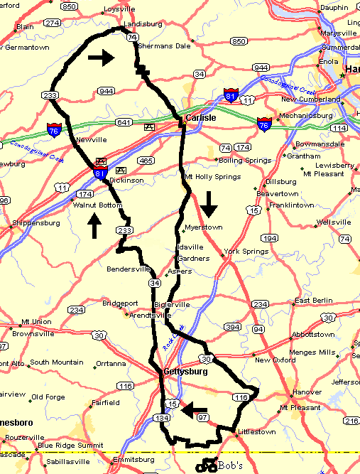
It was 5:18 p.m. We were fifty-two minutes behind the fast pace schedule card and thirty-one minutes behind our slow pace schedule. The time I wasted on my recovery put a dent into our schedule. So, without much thought, we switched to the slow pace schedule as our goal. From where we started, we could see the whole mountain covered with fog. This was our second steepest climb for the day. Both were within a span of twenty-five miles. Waggoners Gap had the narrowest shoulders of any of the mountains we climbed, so we had to be careful. Reeling from the effects of the "bonk," I felt wobbly climbing. Obviously, there would be no Tour de France moves going up this mountain. Bob made it to the top before I did. I kidded him about this since he was hardly one to beat me to the top of big hills. We did manage a 5.5-mph average speed ascending Waggoners Gap. Wet roads and poor visibility had repeatedly robbed us all day of fun downhill runs. This one was no different. Our visibility was limited to about thirty yards. When we reached the bottom of Waggoners Gap, I quickly got behind Bob to draft him most of the way to Carlisle. This was an attempt to continually revive me and perhaps stockpile some energy for the last forty miles of the trip.
![]()
When
Bob and I reached the south side of Carlisle, most of what I had done to
recuperate had worked. I had to think positive to forget all that happened the
last hour. Between Carlisle and Mount Holly Springs, the roads were flat. During
this segment, drafting was very effective for both of us. This was much better
than Bob toeing the line. Besides, I did not want to be the slacker for the
remainder of the trip. We were preparing ourselves for the eighth and final
climb, the South Mountain. The time was 6:28 p.m. with only two and a half-hours
of daylight remaining. We picked up twelve and a half minutes of lost time since
the ascent of Waggoners Gap and hoped to gain even more time on our next ascent.
After passing by the Deer Lodge in Mount Holly Springs, Bob and I turned onto
Route 34 toward Biglerville. This passage was six miles longer than taking Route
94, but we planned on less traffic to contend with and better shoulders on which
to ride.
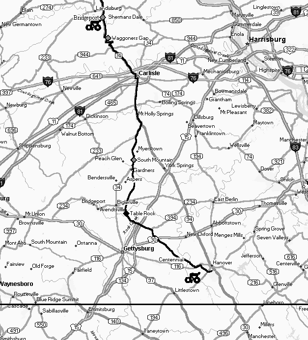
We had previously been on the South Mountain twice for
training rides. This climb is extremely long. Each time Bob and I were on it, we
already had put in many miles before we had reached this point. For the first
time all day, the sun came out as we were ascending this mountain. Making their
presence known were the humidity and high temperature, which was pushing 80
degrees. Hardly exposed to these elements all day, this created an awkward
feeling. At any rate, Bob and I were chugging along and just going where our
tired legs took us. No strategies or plans for this final hill, just plain, old
cycling.
Immediately after cresting the summit, Bob and I rendezvoused with our support team to replenish our food and drink supply. The time was 7:04 P.M. We gained another seventeen minutes on the schedule with that last climb. This put us just two minutes behind our slow paced schedule card. During this short break, I felt my knees and Achilles tendons were beginning to hurt. Bob was having similar aches and pains. When Ken and Mark asked about our condition, Bob summed it all up by saying, "We're surviving!" A few weeks earlier, Bob urged me to buy cycling underwear. Since I was having no problem with chafing, I must say his advice was extremely helpful. With only twenty-six miles to go, we simply ignored the pain and concentrated on the finish. For the first time all day, we put wet towels around our necks to cool down. We made this stop a quick one. Having crossed the Adams County line, we were thinking about how close we were to home. Like Dorothy in The Wizard of Oz, I kept thinking there is no place like home. Enough with Emerald City, it was time to enjoy the descent. Besides being relaxing, the downhill run primed us for a few rolling hills through orchard country.
Just north of Biglerville, we turned off Route 34 onto Table Rock Road. Bob and I were gliding along on this road. Looking ahead and to our left, we could see a bad storm brewing. Being in the rain for the better part of the day, one more drenching would not have mattered. The difference here was the presence of lightning. Common sense dictates that lightning and bicycles are a dangerous mix. Surely, Bob and I had common sense. Who else rides their bikes two hundred miles over eight mountains in a single day? So the storm was something we had to keep our eye on. Luckily for us, the lightning never appeared, but we did get soaked again for the "gazillionth" time. For the first time all day, Bob and I noticed something unusual about this trip. For hours, we had ridden across the state of Pennsylvania and did not see any other cyclists! Imagine that! It must have been the weather.
Finally, we passed through Table Rock. Turning onto Schriver's Corner Road to get us in the direction of Hunterstown, we picked up our pace. A half-mile into this road, Bob's right pedal axle broke. Our first bike failure was upon us. By a stroke of luck, Mark and Ken passed by just as it happened. Bob had spare pedals along and he made the repair in about five minutes. We also took on food and fluids during this unscheduled stop. Bob now had a clipless pedal on his left side crank and a pedal with a clip on his right side. This was an awkward and slippery combination because his shoes were fitted with cleats for the clipless design. There was no time to be fiddling with pedals and shoes right now. We had work to do.
The time was 7:43 P.M. and we still had fifteen miles to go. The rain was slowly fading away, but the puddles were plenty. Bob and I worked our way past the Route 15 overpass and through Hunterstown. Ken and Mark were along the side of the road cheering us on. We continued working on picking up the pace. Our average speed on this stretch of road was 15.48 mph. We crossed Route 30 and turned southward onto Centennial Road. Both of us were feeling so good about our accomplishment at this point that the aches and pains were virtually nonexistent. Ken and Mark stayed with us from here on in. With determination, we picked up the pace to 19.4 mph as we approached the town of Centennial. From a trivial viewpoint, we eclipsed the two hundred-mile mark as we were going through Centennial. Bob and I had just a little bit to go. Our support crew was driving along side of us to spur us on and put this ride under our belt.
When we reached Route 116, we turned east toward McSherrystown. Mark and Ken had previously planned with Bob and me to stop on Academy Street to change clothes. We had not found an appropriate time to change our clothes all day. Our support crew thought it would be best to look civilized at the finish line. They arranged for a welcoming crowd to be there to greet us. Admittedly, it was a relief to change after pedaling two hundred miles in wet clothes. The time was 8:40 P.M. when we began our final segment. Bob and I rode up South Street and turned on Fifth Street toward Blettner Avenue. Ken and Mark continued to escort us the rest of the way in as darkness was settling in.
As Bob and I crossed Frederick Street, our families greeted us. What a great way to cap off a two hundred mile bike ride! We slowed down some but did not stop completely because we had to make it to my house to make it official. Bob and I both knew how hard it would be to start pedaling again after another stop. As we neared my house, we decided to continue up to the next street and back to make the trip exactly two hundred five miles.
All the training, time, and planning came down to this moment when we made it home by dark. Our trip ended at 8:51 P.M. We had spent fifteen hours and thirty-three minutes in the saddles. The average speed for the trip was 13.18 mph. We had planned our work and then worked our plan. Words cannot express how we felt. Physically, I am sure we had a long list of maladies. The experience of completing two hundred five miles over eight mountains in one day would last for quite awhile! I remember sharing with Bob in the final minutes of the ride those things that I thought made it successful. Many prayers, much food and an excellent support crew. These things, along with determination, enabled us to meet the challenge. Because on that day, we truly had magic legs!
by Robert Zinn
Convincing Joe that we should do this 205-mile trip in one day was not an easy task. Joe's longest ride before we began our training was 75 miles. His absolute commitment to the one day trip was not anchored until midway through our training.
Looking back to the beginning of our training, we both struggled on the Pine Grove Furnace ride. We felt so bad after riding those 76 miles that we had problems persuading ourselves that we were capable of riding 200 miles in one day. This was not good for our confidence levels. After the Catoctin Mountain ride we were upbeat. We had great time climbing the mountain and had a strong tail wind during the ride home.
Training rides did not come and go without their lessons. The Pigeon Hills (Hiller Thriller) ride was a struggle for Joe. The First Century ride was an exerting effort for me. These rides taught us about the absolute necessity of avoiding the "bonk". Learning from our struggles, we focused on nutrition and carbohydrate loading as part of our training.
After the pain subsided from the First Century ride, Joe was a changed man. His enthusiasm and confidence was unswerving. Joe was now totally committed to the 200 mile, one-day ride. During the Second Century ride, not even a rain storm could stop this guy. I was ready to cut that trip short, but Joe's upbeat attitude kept me from even suggesting it. Joe was now on a mission.
Training only 800 to 900 miles and completing a 205-mile bike ride is an achievement. The success relied on teamwork. Each rider helping the other get past the struggles, as well as sharing the accomplishments. This adventure with my long-time cycling friend is full of strong and vivid memories that will last forever.
Distance: 205 Miles
Average Speeds:
Rotations of bicycle Wheel: 155,592
Counties passed through: 10
Mountains conquered:
| Joe's Bike | Bob's Bike | |
|---|---|---|
| Model: | 1979 Soma Cosmopolitan | 1979 Soma Sport (modified) |
| Weight: | 32 pounds | 25 pounds |
| Wheelbase: | 42 ¼ inches | 40 ½ inches |
| Frame: | 25 inch chrome moly steel | 1983 Schwinn 23 inch chrome moly steel |
| Wheels: | Araya 27x1¼ Chrome Steel 36 spoke | Nashbar 27x1¼ anodized 36 spoke NA-UT20 1992 |
| Tires: | 27 1 1/8 clincher, 85 psi | IRC 27 1 1/8 Road Winner II Duro (Kevlar) clincher, 105 psi. |
| Crank: | Tourney 53 teeth/40 teeth | Sugino Maxy 171 mm. 53 teeth/36 teeth |
| Rear Freewheel: | Suntour five speed: 14-17-22-28-34 | Suntour New winner six speed: 13-15-18-24-26-32 1988 |
| Rear Derailleur: | Shimano GS 500 | Shimano Exage 400 LX |
| Front Derailleur: | Shimano Uni Glide 500 | Suntour Spirit. |
| Shifters: | Shimano SIS Stem Mount Shifters. 1995 | Suntour down tube |
| Breaks: | Dia-Comp Center Pull breaks | Dia-Comp G Side pull breaks |
| Break Levers: | Dia-Comp | Suntour Aero SL |
| Stem: | SR | Dia-Comp 120 mm |
| Handlebars: | Steel | Sakae Road - Custom Modulo Anatomic Bend |
| Aerobar: | Profile Aero Clip-on. 1994 | Scott Clip-on |
| Saddle: | Vinyl (original). | Avocet Gelflex Mountain C30 |
| Pedals: | Suntour Superb-Pro 1985 | Welgo Clipless - Shimano SPD Compatible |
| Shoes: | Specialized '94 Ground Control Sport | Specialized '94 Ground Control Sport Shoe |
| Cyclocomputer: | Vetta C20 | Cateye Mitty 2 |
| Gearing Ratio Range: | 31.76 - 102.21" | 30.37 - 110.07" |
| Front Chainring Teeth: | 53 teeth 40 teeth | 53 teeth 36 teeth |
| Rear Freewheel: | 53 tooth/40 tooth | 53 tooth/36 tooth |
| 14 teeth 102.21"/77.14" | 13 teeth 110.07"/74.77" | |
| 17 teeth 84.17"/63.53" | 15 teeth 95.40"/64.80" | |
| 22 teeth 65.05"/49.09" | 18 teeth 79.50"/54.00" | |
| 28 teeth 51.11"/38.57" | 24 teeth 59.62"/40.50" (3) | |
| 34 teeth 42.09"/31.76" | 26 teeth 55.04"/37.38" | |
| 32 teeth 44.72"/30.37" |
Food Consumed by each person:
| Quantity | Calories |
| Cereal: 7 oz. |
763 |
| Milk: 16 oz. |
240 |
| Cytomax drink: 168 oz. |
1,400 |
| Water: 24 oz. |
0 |
|
Snackwell Bars: 17 bars |
2,210 |
| PowerBars: 3 bars |
675 |
| Peanut Butter & Jelly: 1 sandwich |
230 |
|
Raisins: 6 oz. |
372 |
| Apple sauce: 4 oz. |
100 |
| Bananas: 2 bananas |
208 |
|
Milk: 8 oz. |
120 |
| Tea: 24 oz. |
180 |
| Ravioli: 6 oz. |
180 |
| Noodles & Meatballs: 6 oz. |
193 |
| Cup Cakes: 2 |
256 |
| Pretzels: 2 |
110 |
| Aspirin: 2 |
0 |
| ----------- | |
| Estimated Calories Consumed: |
7,237 |
|
======= |
Time Card Schedule
: Minutes Ahead/Behind the Schedule:
The chart below shows the Actual Pace time difference from both the Fast Pace Schedule and the Slow Pace Schedule. For example: At mile mark 160, we were 50 minutes behind the Fast Pace Schedule. Direct vertical drops in the lines indicate that we stopped for a break. Gradual rises in the lines indicate gaining time on the schedule. Falling lines indicate that we are riding slower than scheduled.
Elevations and Locations:
The chart below shows the elevations or topography of the trip. The locations of towns and mountains are labeled for referencing points. Elevations were recorded every half mile and represent feet above sea level.
Elevation Change per ½ Mile:
The chart below shows the elevation climbed or descended for every half mile ridden. This chart is a good clear measurement of effort required by the cyclists during that half mile segment. The climb to Piper at mile mark 50 did not require as much effort as the climb up Waggoners Gap at mile mark 160. Looking at the previous "Elevation Chart", The Piper mountain climb is higher, but not as steep as Waggoners Gap. This chart is useful because it can be used to show the amount of effort required when riding a course in any direction.
Speed Per Elevation Change:
The chart below shows the speeds attained while descending or ascending a given number of feet per half mile. This data along with the "Elevation Change per 1/2 Mile" chart is the basis for determining how long it will take to get from point A to point B. Looking at the chart, you can see that traveling 1/2 mile on perfectly flat land will obtain a speed of 18.94 miles per hour. Additionally, climbing 50 feet over a half mile will provide speeds of 11.9 mile per hour. This data was based on our riding performances during previous training rides. With this knowledge you can accurately predict how much time it will take to travel any half mile segment once you know the elevation foot change for that same segment. This is the basis for the time predictions in the "Schedule Card". Note: A fatigue factor of 20% over 200 miles was used for projected times.
Average Speeds:
Below is a chart showing projected average speeds achieved for the duration of the trip. It is common for average speeds to eventually drop over time on a mountainous trip. Averages shown are for Scheduled Fast Pace, Scheduled Slow Pace, and Actual Average Speeds. The graph shows the average speeds achieved from the start of the ride to that point into the ride.
DeMoss, Virginia. "Eater's Digest," Bicycling's New Cyclist 1994
Clark, Nancy, MS,RD. "Carbohydrate Loading: Tips for Endurance Athletes" SportNutrition: SportsMedicine Systems, Inc.
Clark, Nancy, MS,RD. Nancy Clark's Sports Nutrition Guidebook.
Ferguson, James M., M.D. Habits, Not Diets, 1988.
Skinner, Elizabeth and Charlie. Bicycling The Blue Ridge. Menasha Ridge Press, 1990.