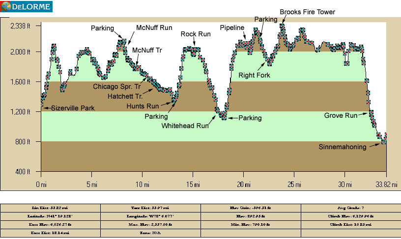
Day 2From (Start 8.8 to 10.4 miles) to (mile 22.4-Right Fork water
OR mile 23.6 Brooks Fire Tower) |
| If Camped at McNuff Run (Mile Mark 8.6) |
13.8 to 15 total miles for Day 2 |
| If Camped at McNuff Trail (Mile Mark 9.25 ) |
13.15 to 15.35 total miles for Day 2 |
| If Camped at Chicago Springs (Mile Mark 10.4) |
12.0 to 13.2 total miles for Day 2 |
Notes:
- Water available at McNuff Run (Mile Mark 10.4 through 13.2)
- Parking available at mile mark 13.2 (Hunts Run Road and More Draft)
- Water may be available at Rock Run (Mile Mark 15.0)
- Water should be available at Whitehead Run (Mile Mark 17.4 through 17.9)
- Pack water at Whitehead Run Mile Mark 17.9
- Parking Available at Mile Mark 17.9 (on Whitehead Road just off Hunts Run Road)
- Parking available at mile mark 21.5 (along Ridge Road and Stillhouse Road)
- Water my be available at Right Fork (Mile Mark 22.0 through 22.4)
- Spring is available on Brooks Run Road 1/2 mile east from Mile Mark 24.4)
|
Day 3From (Start 22.4 to 23.6 miles) to mile 34.0 Sinnemahoning) |
| If Camped at Right Fork (Mile Mark 22.4) |
11.6 total miles for Day 3 |
| If Camped at Brooks Fire Tower (Mile Mark 23.6) |
10.4 total miles for Day 3 |
| If Camped at Chicago Springs (Mile Mark 10.4) |
12.0 to 13.2 total miles for Day 2 |
Notes:
- Parking available at mile mark 21.5 (along Ridge Road and Stillhouse Road)
- Water my be available at Right Fork (Mile Mark 22.0 through 22.4)
- Parking available near mile mark 23.9 (along Ridge Road just west of the trail)
- Spring is available on Brooks Run Road 1/2 mile east from Mile Mark 24.4
- Parking available near mile mark 25.7 (along Ridge Road just west of the trail)
- Parking available at mile mark 26.6 (along Ridge Road and Pepper Hill Trail)
- Water is not available until Grove Run Mile Mark 32.3
|